About
From Headwaters to Groundwater
Landscape-scale Leadership and Bold Collaboration for a Resilient Tulare Basin
The Basin is a large, diverse, and vital part of California.
Yet, it is facing real challenges from drought, extreme weather, major regulatory changes, and prior practices.
Our goal is to establish and enhance watershed health and resilience across the Tulare Basin by 2040.
Mission
The Tulare Basin Watershed Partnership mission and vision is to engage partners, stakeholders, and funders in headwaters to groundwater multi-benefit projects that enhance regional ecological and economic health, agricultural heritage, healthy waterways and wildlife habitat, and abundant clean water for nature and people.
Vision
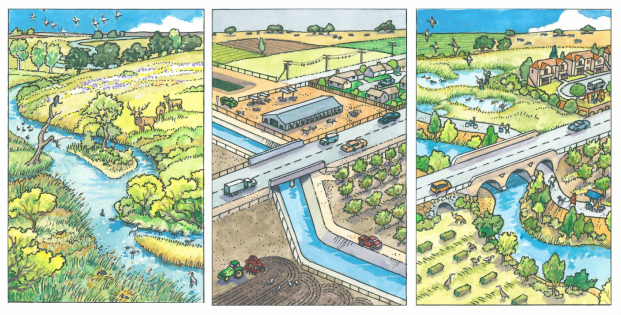
Our vision is to create a healthy regional watershed with ecologically functional waterways, wetlands and uplands that provide abundant clean water for both people and wildlife.
We envision healthy riparian corridors along the mighty rivers and scenic creeks winding from the Sierra Nevada, Transverse and Coast Range mountains to the historic Tulare Lake Bed in California’s southern San Joaquin Valley. Restored wetland, upland and riparian habitats connected along these corridors comprise a healthy, regional watershed that mitigates the effects of climate change, offers clean and abundant water, recharges groundwater and stores flood water to protect thriving local towns. An abundance of wildlife, including more than 100 species of sensitive plants and animals, flourish in the surrounding open space where wildlife-friendly farms and ranches showcase the region’s rich agricultural heritage and diverse farming operations. Scenic vistas and natural areas offer recreational opportunities for families, enhance educational experiences for our children, and increase business and tourism opportunities for residents and visitors.
Read more about the Tulare Basin Watershed Partnerships' Conservation Vision.Organizational Structure
TBWP is a 501(c)3 non-profit organization consisting of a skilled board, implementation team, and a network of professional advisors, partners and resources. An accomplished board of directors provides guidance and direction, as well oversight and accountability for the organization. TBWP contracts with leading specialists to implement specific projects in a cost-effective manner. TBWP chose this organizational structure in order to be flexible enough to serve project interests while maximizing resources that can be devoted to significant and tangible conservation results.

Where We Work
Located in California's southern San Joaquin Valley, the Tulare Basin encompasses portions of Fresno, Kern, Kings, and Tulare Counties. More than 16 rivers and creeks flow from surrounding mountains into the Basin’s small lakes and wetlands, which once comprised the largest freshwater lake west of the Mississippi River, the historic Tulare Lake. The watershed is bounded on the north by the San Joaquin River, on the west by the crest of the Inner Coast Range, on the east by the crest of the Sierra Nevada, and on the south by the crest of the Tehachapi range. This watershed is approximately 134 miles east to west, 163 miles north to south, covers almost 22,000 square miles, and ranges in elevation from 163 feet above sea level at Mendota Pool to 14,505 feet on the summit of Mt. Whitney.