Tulare Basin Watershed Network
​Contact us: 559.970.6320
  • Home
  • OUR NEW WEBSITE
  • About
    • How We Work
    • Leadership and Team
    • History
    • Partners
    • Contact
  • Our Work
    • One Watershed Series >
      • OW#1: TB Watershed Intro
      • OW#2: Making Sense of Water
      • OW#3: Groundwater Management
      • OW#4: Native Lands
      • OW#5: Climate Change
      • OW#6: Forest Management
      • OW#7: Flood History
      • OW#8: Environmental Justice
    • Tulare Basin Watershed Initiative >
      • Reports
    • Central Valley Joint Venture 2020 Implementation Plan
    • AAAT Project
    • A+A WBL Program
    • Tulare Basin Working Group
    • Conceptual Project List
    • Tulare Basin Regional Conservation Reports >
      • Buena Vista/Kern Lake
      • Goose Lake
      • Sand Ridge/Tulare Lake
      • Riparian & Wildlife Corridor
      • Water Supply Strategies Report
      • Fresno County Corridor Report
      • Tulare County Corridor Report
    • Conservation Toolkit >
      • Land Protection
      • Land Restoration
      • Resources
  • TBWP Network
    • Tulare Basin Watershed Connections Collaborative
    • Adaptation & Mitigation News and Legislation
    • Integrated Regional Water Management >
      • IRWM Plans
    • Sustainable Groundwater Management in the Tulare Basin >
      • Tulare Basin GSAs & GSPs
    • Climate Change Adaptation Solutions >
      • Land Use and Natural Resource Integration
      • Integrated Resource Management
      • Climate Change Adaptation Projects in the Tulare Basin >
        • Conceptual Project List
    • Local Rural Community Resources
  • About the Tulare Basin
    • Water >
      • Hydrology
      • History
      • Floods and Droughts in the Tulare Lake Basin
    • Habitats >
      • Herbaceous Plants
      • Shrubs
      • Trees
      • Vernal Pools
    • Species >
      • Wildlife
      • Plants
    • Maps
    • Recreation and Education
    • Glossary of Terms
  • Donate

We have a new website!! 

The Tulare Basin Watershed Network (formerly Tulare Basin Watershed Partnership) has a new website:  www.TulareBasinWatershedNetwork.org
OUR NEW WEBSITE

Announcements


​The TBWP is excited to announce that the TBWPN has been awarded a Network for Landscape Conservation 2021 Catalyst Fund grant! This funding will go towards continued Network facilitation by Ag Innovations as well as Network capacity building and outreach for the duration of 2021 and into 2022. 
Picture

​The TBWP is pleased to announce that Edison International/Southern California Edison has renewed its support for the Tulare Basin Watershed Initiative, specifically for continued coordination of the Tulare Basin Watershed Partnership Landscape-scale Watershed Network formation during 2020-2021.
Picture

​The TBWP is now working with Ag Innovations and key regional partners to formally launch the effort under a new title: Tulare Basin Watershed Partnership Network.
​​For more information about this, please contact 
[email protected].
Picture

Our Mission

The Tulare Basin Watershed Partnership mission and vision is to engage partners, stakeholders, and funders in headwaters to groundwater multi-benefit projects that enhance regional ecological and economic health, agricultural heritage, healthy waterways and wildlife habitat, and abundant clean water for nature and people.

Where We Work

Tulare Basin
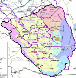
Located in California's southern San Joaquin Valley, the Tulare Basin encompasses portions of Fresno, Kern, Kings, and Tulare Counties. More than 16 rivers and creeks flow from surrounding mountains into the Basin’s small lakes and wetlands, which once comprised the largest freshwater lake west of the Mississippi River, the historic Tulare Lake. The watershed is bounded on the north by the San Joaquin River, on the west by the crest of the Inner Coast Range, on the east by the crest of the Sierra Nevada, and on the south by the crest of the Tehachapi range. This watershed is approximately 134 miles east to west, 163 miles north to south, covers almost 22,000 square miles, and ranges in elevation from 163 feet above sea level at Mendota Pool to 14,505 feet on the summit of Mt. Whitney.
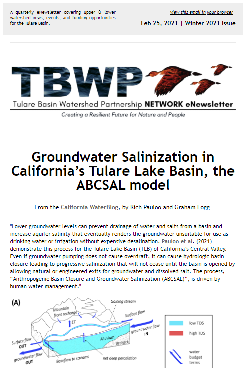

TBWP Network News


TBWPN Landscape-scale Resilience Strategies for Tulare Basin Learning Sessions 1 & 2

Check out the Winter 2021 issue of the Tulare Basin Watershed Partnership Network eNewsletter & subscribe!
Picture
Sign up for Watershed News

The McMullin Area Groundwater Sustainability Agency (MAGSA) awarded $10 million grant to expand innovative On-Farm Recharge project
Picture

Powered by Create your own unique website with customizable templates.