"One Watershed" Series
|
#2 Making Sense of Water in the Tulare Basin
Tulare Lake watershed demand exceeds supply by 42% April 30, 2015
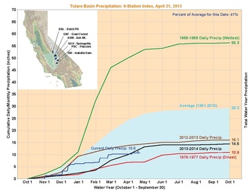
Water. It’s on everyone’s minds. But how much do we know about where it comes from, where it goes, and what “normal” even means? California's water story is a complicated one, and the Tulare Lake watershed introduces its own twists and turns to the plot. As consumers of this limited yet vital resource, we can’t afford to overlook the details of the story. This article will touch on some of those details. Water in the Tulare Lake watershed comes from: 1) surface water that travels from the headwaters of our large mountain “reservoirs” as snowmelt or runoff, which then gets stored in various foothill lakes to be distributed via a network of canals, 2) water imported from the wetter climates of Northern California via the State Water Project (California Aqueduct) and the federal Central Valley Project (via the Friant Canal and the Delta-Mendota Canal), 3) groundwater that is pumped from underground reservoirs or aquifers, and 4) a combination of smaller sources like recycled and reused water. The amount of water from each of these sources varies dramatically depending upon the amount of precipitation the watershed receives in a particular year. (See more on this in the “Water Balance,” section below.) Precipitation in California, and our region, varies dramatically. “The Tulare Lake Basin doesn’t have normal conditions in the sense of a statistical average. What is reliable about our climate is its extreme and relentless variability. That is our real normal,” writes John Austin, author of “Floods and Droughts in the Tulare Lake Basin,” a rich chronicle of reagional weather patterns in the past 2,000 years.[i] We all know that California is prone to droughts and floods, but many of us are unaware of how massive those fluctuations can be. “Society increasingly relies on a stability of climate, but that is not supported by the last 2,000 years of history… We should not be complacent about floods and droughts,” writes Austin.[ii] Some researchers are calling this the worst drought in 1,200 years, based on low levels of precipitation and record high temperatures. But as devastating as the current drought is, a catastrophic 500-year flood may be just around the corner. As we collectively cross our fingers for rain, it’s hard to imagine that we might also need to be preparing ourselves for the inevitability of too much rain. Are we prepared?  Tulare Basin Precipitation, April 21, 2015. Source: California Data Exchange. (Click to view larger image.) Tulare Basin Precipitation, April 21, 2015. Source: California Data Exchange. (Click to view larger image.)
What is Normal? The Tulare Basin is one of the most arid regions of California. It receives an average of 29 inches of precipitation per year, aggregated for the entire watershed, from the mountains to the valley floor. In contrast, the Northern Sierra region receives 50 inches per year.[iii] The difference between upper and lower watershed precipitation, however, is dramatic. While Corcoran (an approximate midpoint of the watershed) receives an average annual rainfall of about 7.5 inches, the Sequoia National Park at Lodgepole receives an average of 45 inches of precipitation. The real problem we’re seeing in the current drought isn’t just the paltry precipitation on the valley floor, it’s the lack of snow at higher elevations, as well as warming temperatures that melt it prematurely. Currently, the valley floor has received 41% of its average rainfall for a year at this time, a little worse than this time last year. Snow pack, on the other hand, is only at 3% of its average for this time of year.[iv] Scientists have long predicted that climate change could have adverse impacts on California’s precarious balance of water supply and demand. Climate change models indicate that warming temperatures will reduce total snowpack accumulations – the watershed’s largest natural water storage – and will hasten the pace at which that snow melts. It’s increasingly more difficult to ignore the effects of climate change. Dick Moss, Vice President of Provost and Pritchard Engineering Consultant and Vice President of the Tulare Basin Wildlife Partners, said, “If you want to see the kinds of change we can expect from climate change, drive up Highway 180 and see what’s happening at the 4,000 foot level where all the pines are dying off.” |
Mission: To raise awareness about the Tulare Lake Watershed and its unique attributes, challenges, and opportunities. From the snowy peaks to the valley floor, we are one watershed.
This project is made possible by grant funding from the Fresno Regional Foundation.
This project is part of the Tulare Basin Watershed Initiative.
HELPFUL LINKS:
Other articles
|
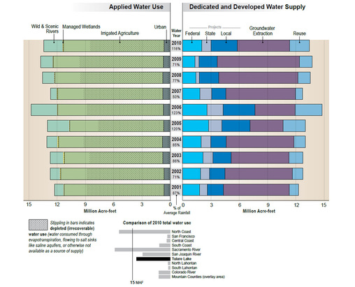
 Tulare Basin Applied Water Use and Supply Sources. Source: California Water Plan Update, Volume 2, Tulare Lake. (Click to view larger image.)
As the dryer, hotter climate of the valley and foothills creeps up the mountain slopes, not only does the forest composition change, but fire risks increase and cold-temperature snow storage shrinks. Collaborative problem-solving processes such as Integrated Regional Water Management planning are working to address these issues. We can all support these efforts by learning more about our water supply and participating in efforts to conserve it.
The California Department of Water Resources has over a dozen staff members working full time on climate change. Regionally-based climate change specialists provide information about current and projected impacts of a warming climate and work with local water managers to identify strategies to deal with them. “While this challenge is very daunting, the encouraging news is California water managers are already accustomed to dealing with high variability and alternating periods of drought and floods. The key to adapting to future climate change will be working across non-traditional boundaries and embracing an integrated resource management approach”, according to Michelle Selmon, a member of DWR’s climate change staff.
The California of tomorrow may look a little different than the California of today, and grass landscaping will become a relic, but if we work together, based on sound information and knowledge, then we’ll find the right balance.
Water Balance
The quantity of water that enters the Tulare Lake watershed varies greatly as a result of California’s irregular precipitation patterns. In years of minimal precipitation, when surface water flows are reduced (limiting water imports and spring run-off from the mountains), groundwater pumping makes up the difference to meet demand and achieve regional water balance. How large is that difference? Between 2001 and 2009, the percentage of groundwater use fluctuated between 33 and 70 percent of total water supply.[v]
Understanding how variable the region’s water supply is is a requirement to discussing the more heated side of the issue: demand. Water demand is usually assessed based on three general categories: agriculture, urban, and environmental uses. These figures get reported in different ways, often omitting relevant details, which creates confusion. The California Department of Water Resources reports figures for applied water, which is, “the total amount of water that is diverted from any source to meet the demands of water users.”
Each hydrologic region in California has vastly different splits on their water use. The Tulare Lake watershed is the largest agricultural region in the state, home to about 3 million acres of irrigated agriculture (the total watershed is about 11 million acres). Therefore, its agricultural water consumption is significantly higher than every other region of California. Between 2001 and 2010, the average percentage of agricultural water use was 82.5% (about 10.8 million acre feet out of a total of 13 million acre feet in applied water).[vi] With a relatively small, though steadily growing population (2.27 million people in 2010), its share of urban and industrial water use was only 5.7% over the same 10-year period. Environmental demand, mainly used for wild and scenic rivers, consumed 11.9%, of which .07% was used for managed wetlands. For comparison, the state’s average during the same ten-year period was as follows: 42.4% for agriculture, 11.1% for urban, 46.5% for the environment (including wetlands, instream flow, required Delta flows, and wild/scenic rivers).[vii]
The bigger picture, however, is that demand exceeds supply in all but very wet years. In dry years like 2009, the difference between water entering the region (via precipitation and imports) was negative 5.36 million acre feet of water. In other words, the Tulare Lake watershed demand exceeded supply by 42% (based on applied water and total water leaving the region, including that by evaporation and runoff). The difference is made up by groundwater pumping, resulting in significant overdraft.
“The biggest challenge this region faces is chronic water shortage, as has been manifested by groundwater overdraft,” said Moss.
The region’s water imbalance is not news. About 80 years ago, water engineers began planning for the Central Valley Project, and later, the State Water Project, to address groundwater overdraft and facilitate agricultural and urban growth. Farmers banked on a steady supply of water imports. However, droughts, urban growth, crashing aquatic ecosystems and regulatory changes collided with that expectation, resulting in ongoing groundwater overdraft that now threatens long-term water supply. Places like Lindsay and Terra Bella, which rely heavily on surface water imports, have been having an exceptionally tough time. “Ten thousand acres of citrus were taken out of production last year. This year, it’ll be much more dramatic,” said Moss of the drought’s ongoing impact to agriculture, especially in areas relying primarily on surface water.
Of the region’s total agricultural acreage, about half a million is planted in almonds and pistachios. The next most widely planted crops are vineyards (346,800), corn (342,800), and alfalfa (315,700). Year-round crops like nut trees, grapes, and other orchards put additional strain on the region’s precarious balancing act in drought years because they require water each year, regardless of precipitation patterns. But economically, these crops have more value.
With the new Groundwater Sustainability Act, long-term sustainability is no longer simply a hope, it is the law. It’s anyone’s guess what that will look like by 2040 when the legislation’s sustainability measures are intended to be actualized, but no doubt, things will look very different than they do now. Drastic measures will need to be implemented in a region like the Tulare Basin, which relies so heavily on groundwater supplies to meet demand. Moss estimates that the Tulare Lake Basin will likely have to take about half a million acres out of production, which is about 16% of the region’s total production. Concerning the process of achieving groundwater to sustainability, he said, “It’s not going to be cheap. And it’s not going to be fun.”
On a more hopeful note, David Mas Masumoto – award-winning author and Fresno-based farmer – recently wrote for the Fresno Bee, “We are witnessing a revolution and we must cultivate our resiliency. It makes for a great story and we are living it with every drink.” [viii]
Onward.
[i] Austin, J.T. 2012. Floods and Droughts in the Tulare Lake Basin. Sequoia Natural History Association, Three Rivers, California
[ii] Austin, J.T. 2012. Floods and Droughts in the Tulare Lake Basin. Sequoia Natural History Association, Three Rivers, California
[iii] California Water Blog, UC Davis Watershed Center for Watershed Sciences and California Data Exchange Center
[iv] California Water Blog, UC Davis Watershed Center for Watershed Sciences and California Data Exchange Center
[v] California Water Plan Update 2013, Volume 2, Tulare Lake Regional Report, California Department of Water Resources
[vi] Figures from the California Water Plan Update 2013, Volume 2, Tulare Lake Regional Report, California Department of Water Resources; 10-year averages calculated by author
[vii] Figures from the California Water Plan Update 2013, Volume 1, Chapter 3, California Department of Water Resources; 10-year averages calculated by author
[viii] David Mas Masumoto: The Story of Water, published in The Fresno Bee, April 25, 2015.


